King Charles III England Coast Path from Wallasea Island to Burnham-on-Crouch: Natural England's proposals
Find out about proposals to improve coastal access in Essex.
Applies to England
Documents

Details
On 29 January 2020, Natural England submitted a collection of reports to the Secretary of State for Environment, Food and Rural Affairs setting out the proposals for improved access to the coast between Wallasea Island and Burnham-on-Crouch (WIB).
The opportunity to comment closed at midnight on Wednesday, 25 March 2020. You can no longer make a representation or objection on proposals.
All representations and objections were considered before the Secretary of State made a final decision about the reports.
You can:
- read the overview report which includes background information to help you understand the proposals and maps
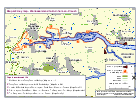
- use the index map to find the relevant report for the length of coast you are interested in
- open the corresponding report for more information
Outcome
On 23 April 2021, the Secretary of State announced their decision to approve the proposals for length WIB1.
On 6 March 2024, the Secretary of State announced their decision to approve the proposals for lengths WIB2, WIB3, WIB4 and WIB5.
NaturalOn England25 willMarch publish2026, furtherthe detailsWallasea Island to Burnham-on-Crouch stretch of the KCIIIECP opened to the approvedpublic. The route inis dueavailable course.to view on the National Trails website.
Updates to this page
Published 29 January 2020
Last updated 625 March 2024
+ show2026
href="#full-history">+ show all updates
-
Details
On 29 January 2020, Natural England submitted a collection of reports to the Secretary of State for Environment, Food and Rural Affairs setting out the proposals for improved access to the coast between Wallasea Island and Burnham-on-Crouch (WIB).
The opportunity to comment closed at midnight on Wednesday, 25 March 2020. You can no longer make a representation or objection on proposals.
All representations and objections were considered before the Secretary of State made a final decision about the reports.
You can:
- read the overview report which includes background information to help you understand the proposals and maps
- use the index map to find the relevant report for the length of coast you are interested in
- open the corresponding report for more information
Outcome
On 23 April 2021, the Secretary of State announced their decision to approve the proposals for length WIB1.
On 6 March 2024, the Secretary of State announced their decision to approve the proposals for lengths WIB2, WIB3, WIB4 and WIB5.
NaturalOn England25 willMarch publish2026, furtherthe detailsWallasea Island to Burnham-on-Crouch stretch of the KCIIIECP opened to the approvedpublic. The route inis dueavailable course.to view on the National Trails website.
Updates to this page
Published 29 January 2020
Last updated 625 March 2024
+ show2026
href="#full-history">+ show all updates
-
Details
On 29 January 2020, Natural England submitted a collection of reports to the Secretary of State for Environment, Food and Rural Affairs setting out the proposals for improved access to the coast between Wallasea Island and Burnham-on-Crouch (WIB).
The opportunity to comment closed at midnight on Wednesday, 25 March 2020. You can no longer make a representation or objection on proposals.
All representations and objections were considered before the Secretary of State made a final decision about the reports.
You can:
- read the overview report which includes background information to help you understand the proposals and maps
- use the index map to find the relevant report for the length of coast you are interested in
- open the corresponding report for more information
Outcome
On 23 April 2021, the Secretary of State announced their decision to approve the proposals for length WIB1.
On 6 March 2024, the Secretary of State announced their decision to approve the proposals for lengths WIB2, WIB3, WIB4 and WIB5.
NaturalOn England25 willMarch publish2026, furtherthe detailsWallasea Island to Burnham-on-Crouch stretch of the KCIIIECP opened to the approvedpublic. The route inis dueavailable course.to view on the National Trails website.